
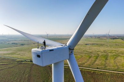
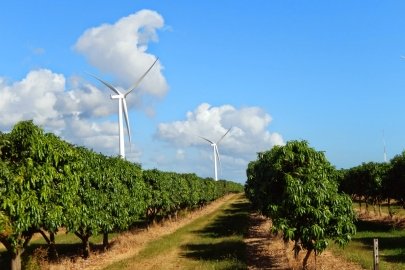
The ability to measure and assess available wind resources is crucial to the development, siting, and operation of a wind energy plant. The U.S. Department of Energy’s (DOE) Wind Energy Technologies Office (WETO) supports efforts to accurately define, measure, and forecast the nation's land-based and offshore wind resources.
Current estimates show that the U.S. land-based wind resource potential spans between 2.2 and 15.1 terawatts—a wide range resulting from uncertainties in estimating conditions and assumptions. In either case, these estimates for wind energy far exceed current U.S. electricity needs.
The 2022 Offshore Wind Resource Assessment conducted by DOE’s National Renewable Energy Laboratory (NREL) determined that offshore wind has 1.5 terawatts of fixed-bottom technical resource potential and 2.8 terawatts of floating offshore wind energy technical resource potential across eight areas in the contiguous United States. Combined, the potential of offshore wind and floating offshore wind represents enough energy to cover three times the U.S. annual electricity consumption.
Wind Resource Maps

Wind resource maps provide wind energy developers and policy makers with a seamless representation of estimated U.S. wind speeds at various turbine hub heights on land and offshore.
When developers plan a new wind power plant, they rely on location-specific data regarding wind speed, meteorological patterns, terrain, and other factors to inform siting and design decisions.
Wind resource maps provide a quick and simple understanding of wind resource potential. These maps also show geographic boundaries and topographic features.
In addition, interactive maps and geospatial data provide wind supply curves, which characterize the quantity, quality, and cost of land-based and offshore wind energy resources.
For land-based and offshore wind resource maps, see DOE’s WINDExchange website.

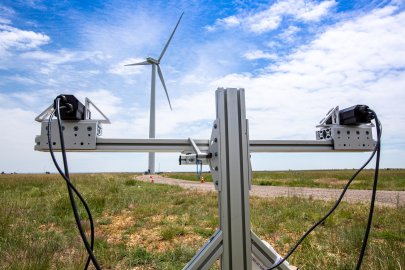
WFIP3 field study assets deployed near the northeast United States outer continental shelf and wind energy lease areas under development
Current Research Projects
WETO leads a portfolio of wind resource assessment projects that will help the industry more accurately predict and measure wind speed, wind direction, and ambient turbulence. This research, in turn, allows wind power plant operators to provide a clean, renewable, domestic power supply to businesses and homeowners at lower costs, while reliably integrating wind energy into the nation's power grids.
For a comprehensive interactive listing of wind resource characterization projects funded by WETO, see our Projects Map and select the program area: Atmosphere to Electrons (A2e) Plant Optimization and Resource Characterization. The projects below feature our research highlights from our atmospheric science and wind resource characterization portfolio.
Atmospheric Science Research
Spatial Analysis for Wind Energy Technology Development
NREL researchers are working to improve the space and time detail that informs understanding of the nation’s wind resource potential. To more accurately characterize the potential wind energy production at individual sites across the country, including land-based and offshore wind energy applications, researchers are adding capabilities and data within the Renewable Energy Potential (reV) model. This work enhances the ability to understand how changes in technology, as well as siting policy and wildlife risks, might impact the nation’s wind energy potential and pathways to increased utilization of wind energy.
Atmosphere to Electrons Initiative
DOE's A2e research initiative is focused on improving the performance and reliability of wind power plants by establishing an unprecedented understanding of how the Earth’s atmosphere interacts with wind power plants and developing technologies to maximize energy harnessed from wind.
The A2e initiative pursues an integrated research portfolio to coordinate and optimize advancements in four main research areas:
- Plant performance and financial risk assessment
- Atmospheric science
- Wind plant aerodynamics
- Next-generation wind power plant technology.
The goal of A2e is to ensure future plants are sited, built, and operated in a way that produces the most cost-effective, usable electric power. Learn more about recent A2e news.
The following are some of the research efforts conducted under the A2e initiative.
AWAKEN
Part of the A2e effort to improve the efficiency of wind power plants, the American WAKE experimeNt (AWAKEN) leverages the experience, instrumentation, and capabilities of multiple institutions to conduct the most comprehensive wind energy wake experiment to date. AWAKEN is designed to gather high-fidelity (highly detailed) observations of wind turbines and power plants operating in representative atmospheric conditions and then use these data to advance the understanding of wind power plant physics.
ExaWind
Another A2e effort, ExaWind is an open-source suite of codes designed for multifidelity simulation of wind turbines and wind farms. This state-of-the-art software tool provides a computer-generated environment where researchers and engineers can test ideas, including potentially disruptive technology, before moving forward with development. ExaWind’s simulations are expected to improve understanding of wind farm physics and, in turn, lower costs associated with wind power plant development. ExaWind was developed with funding from DOE through WETO, the Office of Science, the National Nuclear Security Administration, and the Office of Technology Transitions.
The Wind Data Hub
Another A2e effort, The Wind Data Hub serves as a repository for all data collected through A2e research and is accessible through an open, secure, and easy-to-navigate user interface. Managed by Pacific Northwest National Laboratory (PNNL), The Wind Data Hub also provides state-of-the-science data services crucial for advancing A2e research, communications, and wind knowledge discovery. The Wind Data Hub facilitates community data access, interaction, and collaboration among wind energy researchers, wind plant developers and owners, wind energy consultants, wind turbine manufacturers, and more.
Offshore Wind Resource Characterization Research
Offshore Wind Research Lidar Buoys
PNNL manages two AXYS WindSentinel™ lidar buoys for offshore wind resource characterization on behalf of WETO. The buoys use atmospheric and oceanographic measurement capabilities to capture data, such as wind speed at multiple heights, wind directions, buoy positions, air and sea surface temperatures, ocean current speeds and directions, and wave heights and directions.
The buoys provide long-term offshore wind profile data that supports the research needed to accelerate the use offshore wind data in the United States. Currently, with funding from the U.S. Department of the Interior’s Bureau of Ocean Energy Management, PNNL deploys buoys off the coasts of Virginia, New Jersey, and California, where they gather meteorological and oceanographic measurements to support Bureau of Ocean Energy Management decisions on potential leasing of wind energy sites.
The data collected from the buoys are publicly accessible via the wind data hub. When the lidar buoys are not being used by DOE, they can be loaned to interested parties. This project continues PNNL's path to addressing the grand challenges related to offshore wind resource characterization.
Federal Partnerships
As demonstrated through the A2e initiative, WETO often partners with other DOE offices, government agencies, universities, and industry members to assess and characterize U.S. wind resources. Assessment results are then made publicly available, enabling the wind energy industry to identify areas best suited for the development of future land-based and offshore wind power plants.
Additional WETO efforts supported through federal partnerships include the following.
Wind Forecast Improvement Projects
In partnership with the National Oceanic and Atmospheric Administration, the WETO-led Wind Forecast Improvement Projects are designed to develop more accurate methods for determining wind forecasts. Using targeted wind observations and advanced forecast models and algorithms, this research helps system operators anticipate the electrical output of wind energy plants and, in turn, help manage the contribution of wind energy to electricity grids. The first phase of the Wind Forecast Improvement Project, WFIP1, covered the modeling and improvement of wind forecasts in the Upper Great Plains and West Texas. The second phase of the Wind Forecast Improvement Project, WFIP2, covered the rugged Columbia Basin in the Pacific Northwest.
Wind Forecast Improvement Project 3
The third phase of the Wind Forecast Improvement project (WFIP3) was informed by a workshop on Research Needs for Offshore Wind Resource Characterization. WFIP3 is a DOE-funded project, led by PNNL and Woods Hole Oceanographic Institution, in collaboration with DOE national labs, universities, and local governments, seeking to improve our understanding of the physics of the atmosphere and ocean that dictate the structure and variability of the wind resource with the Marine Atmospheric Boundary Layer.
The team will develop a first-of-its kind high-quality wind resource dataset off the coasts of Massachusetts and Rhode Island and improve atmosphere-ocean simulation tools that will reduce uncertainty in offshore wind resource assessment and improve offshore wind forecasting and grid integration.
National Wind Resource Database
DOE's Wind Resource Database is a public database that provides a collection of modeled wind resource estimates for the United States and various other countries around the globe with data covering timeframes up to over 20 years, with temporal resolution up to 5 minutes and spatial resolution up to 2 kilometers. For a given location covered by a dataset, it is possible to see the wind resource either at a given time or averaged over a certain period. This effort is an update to the previous Wind Integration National Dataset Toolkit— a public data set that supported wind integration studies and energy forecasting tools. This data can be used to develop more robust estimates of offshore wind resources, power production, and design loads, informing and improving the technical and economic viability of wind energy plants.
In addition to funding support from WETO, DOE laboratories have partnered with the National Offshore Wind R&D Consortium and the U.S. Department of the Interior’s Bureau of Ocean Energy Management developing a database that will provide new, precise, and reliable methods for documenting meteorological and oceanographic (metocean) conditions. You can download additional wind resource maps and learn more about wind data sets.
Past Research Project Highlights
Some highlights of past-DOE funded wind resource characterization R&D include wind resource data projects that inform design conditions and siting such as the AWS Truepower U.S. Met Ocean Data Center for Offshore Wind Renewable Energy (USMODCORE), a web-based national inventory that hosts data on wind resource characterization and design needs. Some highlights of DOE-funded wind resource characterization studies include a study co-led by Cornell University and Indiana University using wind data to produce a high-resolution wind characterization for Lake Erie, and a report led by Savannah River Laboratory that examines design conditions that produce breaking waves and the impact on offshore wind turbines.
Wind Resource Assessment and Characterization News
-
 The American WAKE experimeNt (AWAKEN) is compiling the world’s largest and most comprehensive dataset on wind energy atmospheric phenomena, detailing how wind and surrounding air particles interact with wind turbines and wind farms.
 -
 The Wind Resource Database is an online tool that captures information about atmospheric forces that affect how wind turbines perform and how much energy they capture.
 -
 Wind Forecast Improvement Project will Monitor Weather, Ocean, and Wildlife Data Near Active and Proposed Offshore Wind Farms off the East Coast
 -
 A new report for the International Energy Agency Wind Technology Collaboration Programme summarizes the findings of a meeting of global wind energy experts who identify the five Grand Challenges
 -
 DOE is taking applications for the Fiscal Year 2024 Core Laboratory Infrastructure for Market Readiness Lab Call.
 -
 The Renewable Energy Potential model can help identify optimal regions for wind plants based on factors like wind resources, land use, topography, and community preferences. It has revealed pathways to Puerto Rico’s clean energy goals.
 -
 A WETO-funded partnership between General Electric, Sandia National Laboratories, and the National Renewable Energy Laboratory is enhancing data collection efforts to improve the accuracy of wind industry simulation tools.
 -
 Regional wind data from around the U.S. helps improve a national weather forecasting model, which allows utility companies to better plan for windy days.
 -
 A multiyear project advanced understanding of environmental effects, identified existing information gaps, and described future environmental research efforts needed to responsibly develop offshore wind energy projects in U.S. waters.
 -
 In this new article, learn about the types of zoning ordinances in effect and how they could change the amount of available land over time.
Featured Publications
-
 The 2023 edition of the Land-Based Wind Market Report provides an overview of developments and trends in the U.S. wind power market for the 2022 calendar year.
 -
 The U.S. wind industry installed 13,413 megawatts (MW) of new wind capacity in 2021, bringing the cumulative total to 135,886 MW.
 -
 2020's most notable wind energy research and development accomplishments.
 -
 Report summarizes presentations and discussions that occurred during the Workshop on Research Needs for Offshore Wind Resource Characterization.
 -
This first-of-a-kind exploratory analysis characterizes the future opportunity for behind-the-meter distributed wind. Opportunities for behind-the-meter distributed wind are considered from three perspectives: addressable resource potential, economic p...
-
The lidar buoy loan program represents an opportunity for organizations with an interest in offshore wind energy to work with DOE and PNNL.
-
 Report shows how the United States can unlock the vast potential for wind energy deployment in all 50 states.
 -
 This report quantifies Alaska's unique offshore wind resource capacity.