
Highlights
-
 DOE Explains...Earth System and Climate ModelsNovember 23, 2024
 -
The Energy Exascale Earth System Model (E3SM) is DOE’s state-of-the-art Earth system model designed specifically to run on DOE’s supercomputers.
-
In HyperFACETS, scientists are collaborating with regional decision makers to translate Earth and environmental modeling in a way that is both actionable and relevant to people.
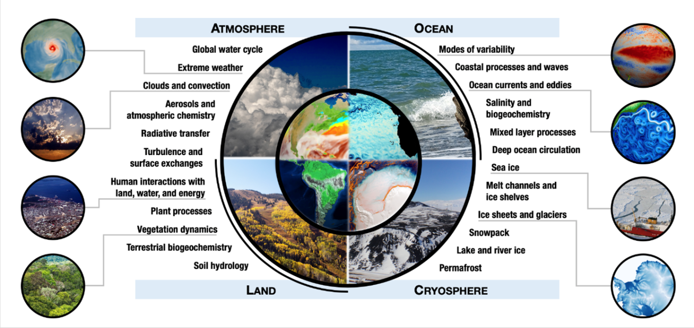
Early System Models Provide Insights into Our Changing World
Earth system models are computer simulations of the past and future atmospheric and environmental conditions. Climate is the long-term pattern of weather variables over decades, or even centuries.
Earth systems models incorporate relevant physics about how energy, gases, fluids, land and ice systems behave. They also integrate key information from measurements, experiments, laboratory analysis, and field observations in the real world. In addition to natural phenomenon, they also include information about human activities such as land and water use, energy production, industrial activity, and more.
DOE strives to produce very accurate predictions with ultra-high resolution. Scientists run various scenarios on these models to predict how different human activities influence the environment, the likelihood of extreme weather, and the suitability of land systems for energy and agriculture.
These predictions help us better understand how the planet works and deliver localized, precise, reliable results. They provide a range of information often tailored to specific stakeholders. Global models can increase our understanding of when ice sheets are likely to melt and how that will affect coastal systems and potential siting of future energy systems. Models can also provide regional or local decisionmakers with information about an area that may flood or experience heat waves. This information can help decision-makers consider where to place new or adapt existing electrical infrastructure and suitability of energy technologies.
The DOE Office of Science Biological and Environmental Research program supports many Earth system models, each with a different purpose. As these models are very complex, many of them also rely on the Office of Science’s supercomputing user facilities. One of these models is the Energy Exascale Earth System Model (E3SM). Able to run on the world’s fastest computers, E3SM is the world’s highest resolution model that combines climate information with details on energy infrastructures.
Ongoing work helps improve the models’ accuracy and precision. The office also supports work where scientists collaborate with stakeholders to make the models as useful as possible to communities and decision-makers.
Introduction to the Energy Exascale Earth System Model
Featured Podcast
-
 While intense storms have splashed across headlines throughout history, the frequency seems to be increasing. Interviews help us explain how climate modeling is helping scientists predict what may lie ahead.May 1, 2024
Press Releases
From Our Blogs
-
- Earth Systems Modeling
- Clean Energy
- Renewable Energy
- Energy Justice
- Research, Technology, and Economic Security
October 30, 2024 -
- Careers
- Clean Energy
- Energy Efficiency
- Renewable Energy
- Earth Systems Modeling
October 21, 2024 -
- Advanced Manufacturing Processes
- Next-Generation Materials
- Clean Energy
- Decarbonization
- Earth Systems Modeling
October 17, 2024 -
- Earth Systems Modeling
- Renewable Energy
- Energy Security
- Clean Energy
- Water Heating
August 28, 2024