
LM Defense-Related Uranium Mines Program receives results from National Nuclear Security Administration aerial survey of large Wyoming mines.
March 11, 2022Early this year, the DOE Office of Legacy Management (LM) Defense-Related Uranium Mines (DRUM) Program received final results from the National Nuclear Security Administration’s (NNSA) aerial radiological surveys of four expansive abandoned mines in Wyoming.
“With this data set, we are now able to evaluate where our priorities are and where to focus our ground teams to complete the normal verification and validation process in 2023,” said DRUM Project Manager and geologist Ian Shafer.
DRUM is a partnership between DOE, federal land management agencies, state abandoned mine lands programs, and tribal governments to verify and validate the condition of abandoned uranium mines that provided ore to the U.S. Atomic Energy Commission during the Cold War.
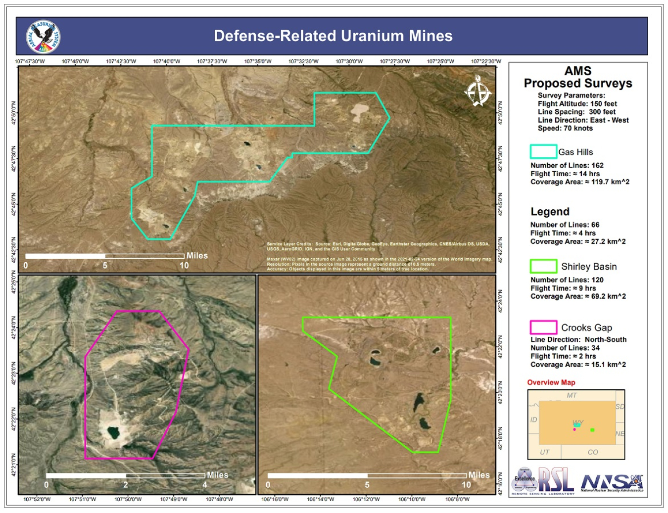
Partnering with NNSA for flyovers to scan the Wyoming mines saved taxpayer dollars, while providing data that would have been difficult, if not impossible, to obtain by DRUM ground crews. A typical abandoned uranium mine covers one to six acres. Since 2017, DRUM ground crews have surveyed roughly 1,800 mines. Located across multiple land management areas in the vicinity of Crooks Gap, Gas Hills, and Shirley Basin, the abandoned Wyoming mines sprawl across thousands of acres, with the largest covering more than 30 square miles -- a daunting challenge for ground crews carrying their equipment on their backs.
To scan the Wyoming mines, NNSA sent out a Bell 412 helicopter, outfitted with 25 liters of sodium iodine (NaI) divided into 12 summed detectors that measure gamma radiation and determine radiological exposure levels. This is a substantially large volume and offers a very high detection efficiency, which is suitable for discriminating background from elevated counts. The flight team mapped the spatial distribution of terrestrial gamma with an added focus on bismuth-214 readings. Part of the uranium decay chain, bismuth-214 can be used to estimate concentrations of uranium.
“Bismuth-214 was selected as the indicator of choice because it emits multiple gamma rays which are prominent in the spectrum, fairly high in energy, and is not complicated by competing gamma peaks,” Shafer said. “In other words, it can point to anomalies related to technologically enhanced naturally occurring radioactive materials that may result from mining activities.”
This was not the first time LM and NNSA have collaborated. According to Shafer, the idea of engaging NNSA’s capabilities for DRUM first came up in 2020, when they flew into the Grand Junction Regional Airport in Colorado to tune their instruments at an LM-managed calibration facility, specifically designed for aircraft-mounted radiation sensor systems.
The information gathered by the NNSA Wyoming flyovers is helping LM plan for follow-up, ground-based sampling. Ultimately, the DRUM work will result in preliminary risk screening to assess whether the mines pose potential risks to human health and the environment and help BLM and Wyoming Department of Environmental Quality make informed decisions about how to address mines that pose the greatest risks.