
Since its inception in 2014, the Lidar Buoy Program has been instrumental in gathering key data to advance the offshore wind energy industry.
Wind Energy Technologies Office
October 2, 2024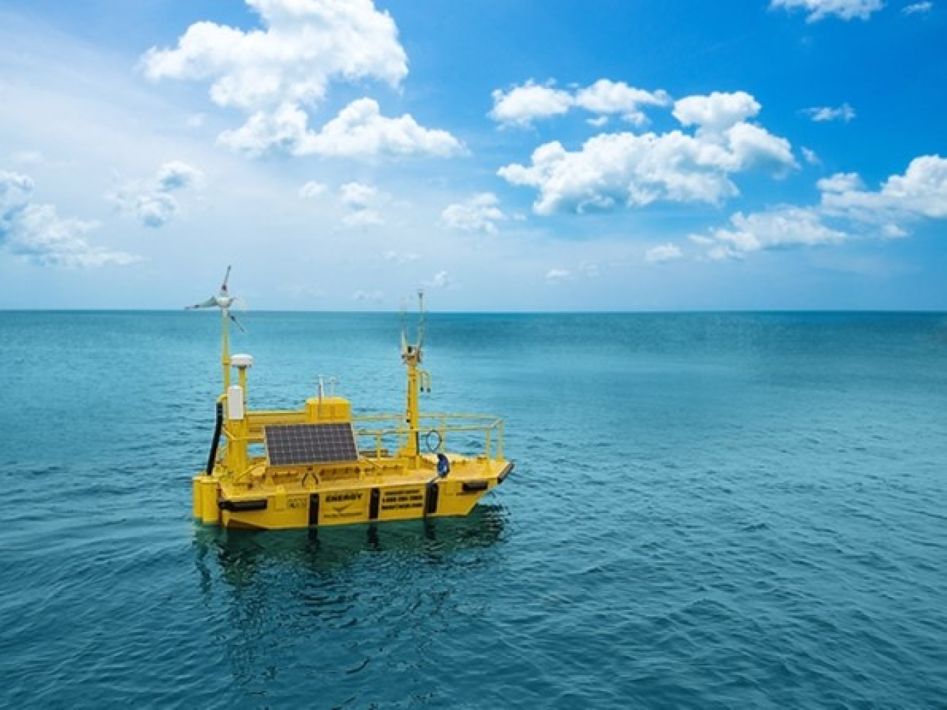
The buoys spent more than a year off the coast of California in advance of the 2022 wind lease sale.
In 2022, two lidar buoys, managed by Pacific Northwest National Laboratory (PNNL) on behalf of the U.S. Department of Energy’s Wind Energy Technologies Office (WETO), had an important job to do: provide key data to potential bidders in a momentous offshore wind lease sale. The five areas for lease, located off the coast of California, had all the characteristics needed to produce large amounts of wind energy—enough to potentially power more than 1.5 million homes. The sale drew more than $757 million in winning bids from offshore wind development companies.
Bidders in the lease sale relied heavily on data provided by the Lidar Buoy Program, which comprises two lidar buoys that are outfitted with state-of-the-art “light detection and ranging” (or lidar) instrumentation. The instruments capture data such as wind speed and direction at multiple heights above the sea surface relevant to offshore wind; air and sea surface temperatures; ocean current speeds and directions; and wave heights and directions.
The data captured by the lidar buoys continue to be valuable to a variety of offshore wind energy stakeholders. “Our calculations show that buoy data have directly translated to measurable cost savings for developers siting offshore wind farms,” said Alicia Mahon, wind energy program manager at PNNL and leader of PNNL’s Operational Systems Engineering Group.
The buoy program was founded with a bold vision: to provide open-access data that would drive the future of offshore wind farms in the United States while fueling groundbreaking science and technology for the wind energy industry. Over the past decade, these buoys have not only realized this vision, but have become indispensable in shaping the future of renewable energy.
“When we began, there weren’t any offshore wind installations in the United States,” said Mike Derby, wind technology program manager at WETO, who oversaw the launch of the program. “So, the buoys were created to get data in support of our new offshore wind demonstration program.” Over the last 10 years, the program has evolved to meet a variety of offshore wind industry and research needs.
The buoys being deployed for validation in 2020
Bobbing Around the Country
Since 2014, the lidar buoys have been deployed in multiple coastal areas with high offshore wind energy potential—they started in Virginia and New Jersey, then moved on to California and Hawaii. After those first East Coast deployments, however, researchers realized some of the original instrumentation had limitations that required key upgrades.
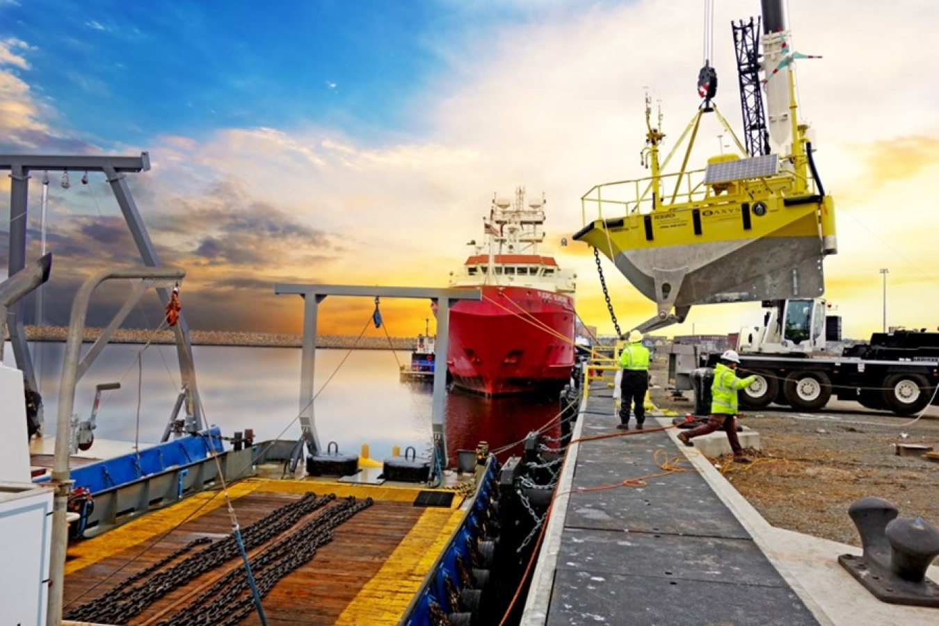
“One piece we upgraded was the lidar system, which is like the bread and butter of these buoys because it captures wind profile information,” said Mahon. But to make the buoy data useful to offshore wind developers, the upgrades needed an independent validation to ensure the accuracy of the data they were producing. And that validation needed to happen in early 2020—at the onset of the COVID-19 lockdown.
“Trying to get contractors out on a boat to perform work in the vicinity of other people in March of 2020, when COVID blew up, was a challenge!” said Mahon. Fortunately, the team managed to complete the validation in time for deployment in California’s wind lease areas.
According to Mahon, that feat was one of the biggest accomplishments of the Buoy Deployment Project, the area of the program responsible for the logistical and operational planning and maintenance required to execute the deployments. WETO’s partnership with the Bureau of Ocean Energy Management is also managed through this area of the program.
The ThermalTracker-3D device, shown on the bow of a buoy here, was installed in the summer of 2021.
Other Notable Accomplishments
The Lidar Buoy Science Project analyzes data from the buoy deployments to validate existing wind and weather models that simulate offshore conditions. “Having a one-year-long dataset, spanning multiple seasons, is important because that data help to increase the certainty of weather models,” said Mahon. “Developers rely on these models to estimate what the wind speed will be and how much power can be produced from a hypothetical wind farm at a certain wind lease area, spanning several hundred kilometers. So having more certainty in those models can drive down the cost of offshore wind energy.”
Buoy data, including information on those validations, are made available in the Wind Data Hub. That means data from the buoys are uploaded in near-real time and are freely available to the general public. Additional processing is conducted by scientists at PNNL, who take the raw data from the buoy in near-real time and conduct rigorous checks to make sure the data are thoroughly reviewed before being used by the industry.
Observationally driven Resource Assessment with CoupLEd models (ORACLE) is another ambitious project that is using data from the buoys. The goal of this large multi-lab project is to enhance the accuracy of resource characterization models in capturing key atmospheric phenomena and offshore wind conditions. This project seeks to carry out a multifaceted analysis combining buoy observations (including from the National Oceanic and Atmospheric Administration), machine learning approaches to characterize offshore turbulence, satellite data, and high-resolution modeling to study the impacts of climate change on future floating offshore wind farms along the U.S. West Coast.
One other major accomplishment: A PNNL-developed ThermalTracker-3D was added to a buoy during a west coast deployment. The tracker uses two thermal cameras to identify the flight tracks of birds and bats in the vicinity of wind turbines. “It can give you the flight height, flight speed, and flight direction of flying animals,” said Mahon, who added that the results from that deployment were published in a Frontiers in Marine Science journal article in spring 2024. The deployment also served to validate the tracking device, which can contribute key information during the environmental permitting process for future offshore wind energy development.
What’s Next for the Buoys
One of the buoys is currently being outfitted with a different type of wildlife monitoring technology in PNNL’s marine sciences laboratory in Sequim, Washington. As part of the Offshore Biological Radar Project, the buoy will be tested to see if it can successfully support a large radar system capable of detecting and monitoring flying animals over open water.
The team is also working with a developer to add a profiling radiometer to one of the buoys. “This would give us a temperature and humidity profile—to complement information from the lidar—that would tell us more about the stability of the atmosphere, which is hugely important for understanding turbine-wake interactions,” said Derby.
Finally, the team has just expanded the buoy fleet. “We had a lot of interest from instrument and sensor developers who could benefit from access to an offshore testing platform,” said Mahon. As a result, a special instrumentation test buoy is expected to be deployed in Massachusetts in fall 2024—near the other existing buoy gathering information for the Wind Forecast Improvement Project-3 (WFIP-3).
And there may be more expansion to come, according to Derby, who says that the team is starting to see more interest in a buoy “loan” program, in which WETO would allow industry or academia to use the buoys as long as they made the results of the deployment free and available to the public.
The buoys have been proven to be a key data source for a wide range of stakeholders over the last decade. While the team had originally considered fixed-bottom stations to capture these data, the buoys’ portability has been key to their success. “That's the real beauty of these buoys—that we can deploy them wherever they're needed,” said Derby.