
Sobering news from experts: Rising populations, regional droughts, and decreasing groundwater levels are draining the nation’s fresh water supply...
Office of Fossil Energy and Carbon Management
May 29, 2013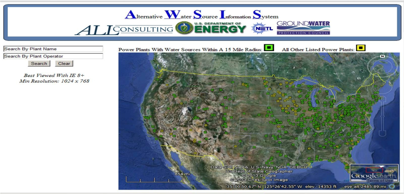
Sobering news from experts: Rising populations, regional droughts, and decreasing groundwater levels are draining the nation’s fresh water supply.
And it’s not just that we’re using that water for our personal consumption; even the electricity we rely on to power our society requires a lot of water. In fact, major energy producers – like coal-fired power plants, which produce about 40 percent of our electricity – require about 150 billion gallons of fresh water per day to produce the electricity we need. That withdrawal rate puts a strain on our fresh water supplies, and the shortages have forced coal-fired power plants to curtail or cease production due to a lack of available cooling waters.
What plant operators need is a system that catalogs in one place nontraditional water sources that can be used for electricity production instead of valuable, limited fresh water. Now, thanks to a Department of Energy-supported project, there’s an app for that.
Working under the Office of Fossil Energy’s Innovations for Existing Plants water program, implemented by the National Energy Technology Laboratory, Tulsa-based Arthur Langhus Layne (ALL) Consulting LLC has developed an internet-based geographic information system (GIS) that catalogs nontraditional sources of water for coal-fired power plants.
The GIS application employs a Google Earth interface to allow plant operators to zero-in on alternative sources of water. Called the Alternative Water Source Information System (AWSIS), the application facilitates in-depth analysis of the location and characteristics of available nontraditional water sources.
Here’s how it works. Using the Google Earth interface, the user can select a power plant by clicking on a map symbol or by searching for a specific power plant by plant name or operator. A pop-up balloon displays basic plant information. With another click, the user can get additional plant information and a summary of alternative water sources within a 15-mile radius – which can include abandoned mine pools, oil- and gas-produced water, saline aquifers, or publicly owned treatment plants. If the summary indicates the presence of alternative water sources within 15 miles, clicking a tab will display its available location, volume, and quality. Only flows above 1,000 gallons per minute, which represents about 20 percent of the cooling tower requirement for a 500-megawatt power plant, have been included in the AWSIS database. And to provide the best possible information, AWSIS will be updated as new data becomes available.
Providing the electricity we need while preserving our supplies of fresh water is a challenge. But with AWSIS, meeting that challenge could be just a few clicks away.
Blog
-
 FECM highlights the new “Basin Scale Issues for Carbon Storage Workshop Report," released on October 7, 2024.October 7, 2024
 -
 The U.S. Department of Energy’s (DOE) Office of Fossil Energy and Carbon Management (FECM) is investing in the education and training of America’s future scientists and engineers through its a University Training and Research (UTR) program.September 16, 2024
 -
 The U.S. Department of Energy’s (DOE) Office of Fossil Energy and Carbon Management (FECM) recently welcomed the 2024 Mickey Leland Energy Fellowship (MLEF) Program cohort of fellows.September 12, 2024
 -
 On August 6, 2024, FECM, in collaboration with the Office of Technology Transitions and the Loan Programs Office, hosted an Appalachia Regional Deploy Dialogue focused on industrial decarbonization.September 9, 2024